Thursday, 22 October 2015

Don't trust the car industry or the press

People and organisations who want people to walk and cycle more focus on providing safe places for people to walk and cycle. They wouldn't dream of encouraging humans to spray themselves in reflective paint so that drivers with headlights can see them even better.

What would be more ridiculous than spraying yourself in paint before going for a walk or a ride - such abnormal behaviour would be without doubt the sign of a failed safety system. 

Car manufacturers however want to sell cars; people choosing to walk or cycle reduces their sales, and Volvo has produced just that product - LifePaint - and is strongly promoting it to tie in with the clock change and fewer daylight hours. Volvo is selling the reflective paint through their car dealers with a supporting press campaign that makes big play of how many people are injured cycling.

The campaign shrieks the number of people injured while cycling in a year in the UK - over 19,000 - but doesn't balance this alarming figure with the government figures that give the wider context:

The total number of pedal cyclist casualties in road accidents in 2013 in Great Britain was 19,438 (16,186 of whom were only slightly injured; not breaking a bone or requiring a night in hospital)
The comparative numbers in 2013 for:
pedestrians: 24,033 (of whom 18,637 were slightly injured)
car occupants: 109,787 (of whom 101,361 were slightly injured)

Maybe cycling isn't so bad after all. But today's Swindon Advertiser puff piece for their local Volvo dealer, Johnson's Cars, and the paint takes scary statistics to another level:
LifePaint washes off and will not damage the colour or surface of material, and lasts more than a month during normal usage.
In 2013, 743 cyclists were killed on the roads and an estimated 48,000 were injured in accidents.
Matthew Coles, the general manager at Johnsons of Swindon, said: “On top of raising awareness about the number of cycling-related injuries happening on Swindon roads, Johnsons of Swindon realises that being environmentally friendly is more important than ever.”
Look at that clever 'raising awareness about the number of cycling-related injuries' - that'll make sure mum won't let her kids cycle to school and won't dream of cycling herself. Much safer to be in her metal box running over other kids she can't see using her headlights while zipping along, all because the stupid brats aren't sprayed in paint or fed Ready Brek.

Whoa now, hang on though - how has 19,000 injured now become 48,000. A previously invisible 29,000 injured cyclists have just come into sight? 743 killed! That's a shocking figure, especially compared with the government's figure of 109.

Has Volvo been spraying LifePaint over the government report to reveal a hitherto unseen layer of injured people? Volvo have got the magical ability to produce people out of thin air as Nikki Rooke, the head of corporate communications, events and sponsorship for Volvo Cars UK, explains in the article: “It’s about making the invisible, visible.”

Without spraying any LifePaint around, I can shine a headlight on the truth. Volvo, their dealership or the Swindon Advertiser decided to use the American statistics for 2013 in this PR guff.

Don't trust the car industry or the press.


Tuesday, 13 October 2015

Giving up on Quietways or making them Kidways?

Shortly after Quietways and the Central London Cycling Grid were first announced, I renamed them in my mind as Childways and the Kid Grid - at least in Lambeth.

In 2013 Lambeth Council formally adopted a new Cycle Strategy, setting out to be the 'most cycle friendly borough in London'.
Lambeth wants to encourage more cycling and believes that the only way to do this is to make cycling safe and attractive for a broader cross section of people. Anyone who wants to cycle should be able to – women, children, parents, older people – as happens in Denmark and the Netherlands. Our vision therefore is that:
Lambeth will be the most cycle-friendly borough in London where 1- 100 year olds feel safe enough to cycle.
No-one expects a one year old to cycle, but a mum will happily cycle with hers in the Netherlands, and so it is intended to be in Lambeth.

You would think that the Quietways are all about making this vision a reality - children cycling independently to school kind of stuff. But if you look at the promotional statement about Quietways, you'll find no mention of children.
Quietways will be a network of radial and orbital cycle routes throughout London. Linking key destinations, they will follow backstreet routes, through parks, along waterways or tree-lined streets.
The routes will overcome barriers to cycling, targeting less confident cyclists who want to use low-traffic routes, while also providing for existing cyclists who want to travel at a more gentle pace.
Each Quietway will provide a continuous route for cyclists and every London borough will benefit from the programme. This network will complement other cycling initiatives such as the Central London Cycling Grid, Cycle Superhighways and Mini-Hollands.
To develop the new, continuous cycle routes, new wayfinding, surface and junction improvements will be introduced and barriers, such as chicanes, will be removed.
 The truth, I fear, is that Quietways will be feeble things - minor tweaks on what we have now, because they have not been explicitly advertised as being intended for, and designed to be, safe and appealing routes for children to use.


I can see absolutely no point, in the 21st century, as we set out to manage climate change, obesity, population growth, air pollution and poverty, in designing and investing in infrastructure for cycling that isn't suitable for children as well as for adults.

Most of the designs I have seen for Quietways fail to achieve a significant amount of change. They are just tinkering around the edges. All sorts of guff will be spouted about 'gradual incremental change', and that's what you are going to get (if you are lucky) if you set out to design for the wishy-washy, weaselly-worded group 'less confident cyclists'.
.
Ironically, the latest versions of Cycling Superhighways, originally planned to be the preserve of 14+ commuters, are now designed to be kid safe

I've taught on-road cycling to kids in inner and central London for long enough to know that if we want children to cycle (for health, time-saving, fun or to save the planet) we need to create space where parents will happily let their kids cycle. If the Quietways won't deliver that then I think they're a waste of time and money.

How do we design streets for kids and motorists.

If the street will carry a volume, weight and/or speed of traffic that makes a parent afraid it needs cycle tracks. The long Rosendale Road in Lambeth, planned to be part of the Elephant and Castle to Crystal Palace Quietway, springs to mind here - it's plenty wide enough for tracks and motor traffic lanes, though some parking may need to be revised. The council have today announced that it is to remain a through road for traffic - no point closures permitted, so tracks seem to be the only child friendly option here.

Some short adjoining streets, meant for access to homes rather than as a connecting through-road for motor traffic, may currently be being used as rat-runs. If so then these are likely to benefit from banned turns or bollards to prevent motorists cutting through, while letting the kids and adults who live there drive in and out, and cycle and walk safely. The street will be quieter too. Access to homes and to connector roads such as Rosendale remains intact so there's no, or minimal, effect on residents' motoring journey times.

If a parent won't let their kid cycle around, and the kid doesn't think it's fun to cycle there themselves, then more needs to be done.

I think change along these lines on the Quietways is deliverable, but if there is no decision to explicitly design for children to cycle independently then we'll struggle to get anything of use achieved.

This photo shows a child cycling home independently from Rosendale Primary School on Rosendale Road, summer 2016.


Cycling short trips for educational visits in Lambeth

One of Lambeth's excellent primary schools has just tweeted about an educational visit some of their pupils have been on:

 Google estimates it takes about 15 minutes to walk from the school to the synagogue, or 5 minutes to cycle the 0.7 miles / 1.3 kms.
It would probably be no quicker to cycle than to walk this trip, given bike unlocking/locking time (by either mode I suspect it will take a primary school group longer than Google's estimate). However, having at least some of the pupils making some of these short trips by bike would be a good way to build more learning into the educational visit. By the time the pupils are in secondary school they could be cycling on school trips to the South Bank Centre or further afield.

As Lambeth aims to be the most cycle friendly borough in London, I'm looking for examples of educational trips that Lambeth school classes have made by cycle, or schools that would like to give it a go - maybe the council's sustainable travel team could arrange some marshals if needed. Travel to swimming lessons would seem to present an obvious opportunity.

Comments welcome below, or schools could ask their transport contact at the Council or cycle training provider for help.

Update
Here's an interesting example. I don't know how the pupils in their first year of secondary school made their way to Streatham Ice Skating Rink (assuming that's where they went). It's 21 minutes by foot; 8 on a bicycle on relatively quiet streets:


Update 2
Henry Cavendish Year 6 pupils went to the London Connected Learning Centre to day - a perfect 2 mile, half-hour opportunity for some related cycle journey learning (and a ride through Clapham Common)


Thursday, 8 October 2015

Making sense of the Loughborough Junction trial


Within a triangle of A roads, in red above, Lambeth Council are undertaking a (potentially) six month trial of one big road filter - the blue blob above - supported by a few smaller ones. The main motor traffic restriction is at the base of Loughborough Road, a B road that bisects the red triangle of A roads. It is an appealing through-route for those coming north from the South Circular Road, via Croxted Road and Milkwood Road, and continuing north towards central London.
I want to emphasise that I am writing this as, relatively speaking, an outsider to this area, though I have cycled through every street in the area on several occasions in recent years. I very seldom cycle through mainly because I travel less in that direction than others, but also because there there isn't a convenient and intuitive route through here that is useful for me, not least due to the Patmos Road / Vassall Road / Langton Road one-way system (the black square above).

Additionally, until recently Loughborough Road was marred by having a painted cycle lane in the door zone of parked cars, which encouraged close passes and had the risk of dooring. When the road was resurfaced a couple of years ago the borough's Cycle Programme Manager took the opportunity to have the paint put back in a better place (tremendous cost efficiency!) and remove the centre line, which made the road more pleasant to cycle along.


I don't know how many of the primary age children at the playground in the photo above cycle along this road. Even though there is some traffic calming (humps and build outs), the width and straightness of this road means some motorists race along it, and there is often quite a lot of motor traffic passing through this area en-route to somewhere else.
The local Loughborough Junction Action Group worked up a plan to improve the area with Lambeth Council assisted by Lambeth based architectural practice DSDHA.


Following an area-wide consultation exercise PDF, public meetings, and a scrutiny review meeting by Councillors of the Cabinet member's decision, the Council is undertaking a six month trial restricting motor traffic access into and out of Coldharbour Lane, with the exception of buses, emergency vehicles and cyclists. An interim review was required after three months, now to be after eight weeks.

There is no doubt that this is a bold trial by Lambeth Council, given that Loughborough Road was/is a B road (CORRECTION - it turns out it isn't a B road, just a local street). The question, as I see it, is whether motorists from the south should continue to be able to cut through the triangle or should they be required to use the A roads?

A significant consideration should be the development of a lot of new housing (the Oval Quarter) to the north of the triangle. This is designated as low car ownership (as is the area in general), and has excellent public transport and walking and cycling potential. How much traffic should pass through here rather than on the A roads?


The traffic that historically has passed through the triangle now needs to find another route or another mode of travel.

In the first weeks it is clear that motorists used to coming up Milkwood Road will switch to Coldharbour Lane and increase the traffic on this A road, likely to increase congestion on a road that, like much of this area, has plenty of traffic already.

Over time motorists will decide whether this congestion is the best option for them or whether
a) to divert earlier, to Herne Hill / Denmark Hill to the east, or Tulse Hill / Effra Road / A23 to the west.
b) to switch to another mode of travel.

Local motorists also have decisions to make. While through traffic (and associated noise, pollution and risk) in the triangle will be reduced, residents have fewer options of routes to drive than previously (though everywhere remains accessible by car). This, as made clear by the Council during the consultation process, will increase some motor journey times. In particular Coldharbour Lane, pictured above, is likely to have more traffic, certainly in the short term.

Some may be able to, and choose to, alter some of their journey habits - for example, walking or cycling instead for short trips, which most car trips are, or altering their routes (for example, the emergency services may use the area inside the triangle over currently congested A roads, as they are allowed to). Given the continuing population growth (and potential congestion ensuing) and the health benefits of active travel, this is sensibly a desired change sought by the Council, It's a bit carrot and stick, but that tends to be the nature of change.

Public transport - buses in particular - are another important factor though, an essential aid to active travel (walk to the bus stop, take the bus with others, walk to your final destination). The Council need to be monitoring any bus delays and find ways to alleviate them.

A recent public meeting, social media and direct action has made it clear that a number of people resent the measures being trialed.

This doesn't necessarily mean the trial is wrong. The concerns people raise must be checked for validity. Tweaks may need to be made. There may have been some aspects that weren't as well promoted as would ideally be. It may be that residents are happy with the volume of motor traffic (increasing as London's population increases) and want no change, or they may work with the Council to find a better way of reducing traffic here.

What I like about this scheme, warts and all, is that it is a real, rather than a token effort by the Council, and that they worked with a local community organisation to improve things, and I applaud them for that. We expect our politicians to be mindful of the bigger picture, and this includes the need to substantially change travel habits in response to population growth, climate change, and public health needs.


I hope that the Council makes a balanced, considered decision on the back of a sufficiently long trial. If people don't think the current scheme is working then I very much hope they will propose alternative ways to reduce motor traffic in the area, because, like it or not, the status quo cannot be an option going forward.

If you live in, or travel through, the area please email your support or suggestions for improvement to the head of Lambeth's transport team, rmistry@lambeth.gov.uk  

--------------
As I write this another blogger has just written about public consultations. His post is well worth a read


Thursday, 1 October 2015

A wasted underpass


The photo above is the Cycling Embassy of Great Britain's current Good Cycling Facility of the Week - an underpass in Zwolle. It reminded me of a recent trip I made to Redbridge in the north-east of London, so here's a quick post about a couple of their underpasses.

The underpass above is a far cry from a typical British underpass - this one in Redbridge, where the A12 and A406 North Circular connect, is quite a generous one by our standards.
As you'd expect, there are 'No Cycling' signs on the approaches from the other direction (and, as you'd also expect, an informal track defeats the metalwork).

That underpass is just off the bottom of this map and no roads cross the A406, which runs top to bottom  in this photo, until the A:406/A1400 intersection at the top of this photo.

There is however an underpass just above the red line I've drawn, with a pedestrian route connecting the community on the left of the A406, towards Snaresbrook railway station, and the community on the right, which includes the private Spire Roding Hospital and Tesco Woodford Green Superstore.

This is an underpass of Dutch proportions!

Wouldn't it be great to provide a verdant, attractive and truly functional walking and cycling route through this underpass to connect the two communities. This is how it looks now:

Heading east of the underpass, a failing path, unlit at night, to the first of two narrow bridges
and on to the second narrow bridge - mind the join:
The second narrow bridge
A tight turn
 to the ramp that takes you down towards the road
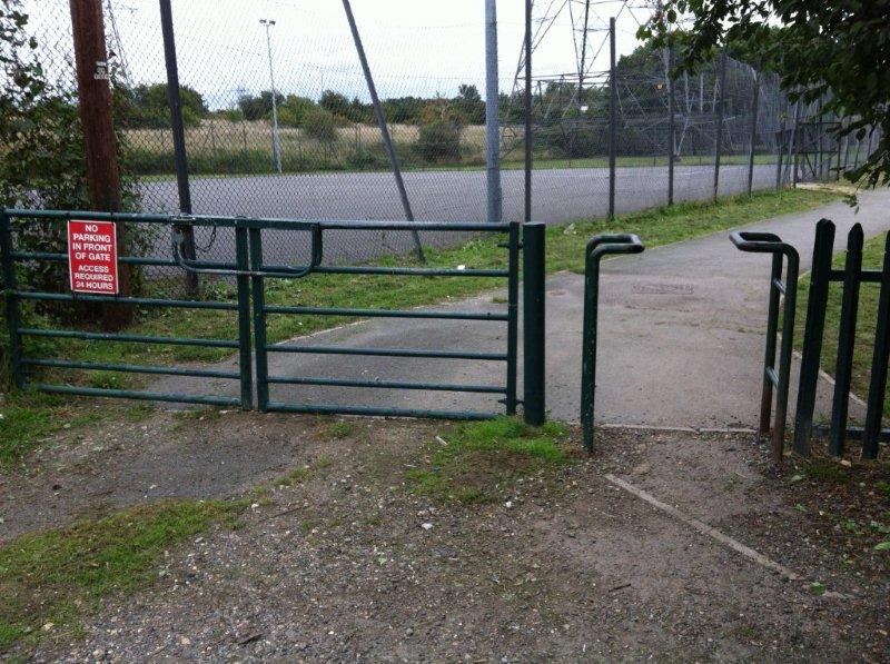
 The other side of the A406 has a path by a playing field, with the usual UK deterrents against use. It also has a typical variety of surfaces, generally poor
 Is it any wonder, given walking and cycling infrastructure like this between local communities, that people choose to drive the long way round to cover short distances? And isn't it tragic that the really expensive part - a quality underpass of a major road - exists.

I suppose we should be thankful that a road hasn't been run through here as I suspect such a large underpass was provided to allow for this.

If only funding was available for proper walking and cycling infrastructure in places like this. Kindly don't mention the Garden Bridge.

Sunday, 27 September 2015

Quietway 5 Waterloo to Croydon - Larkhall section thoughts

Some Lambeth sections of Quietway 5 from Waterloo to Croydon are being consulted on currently - deadline 5pm on Sunday 4th October. Please comment on them. 

It's 8.15am on Friday on the wide and straight Larkhall Rise between Clapham and Stockwell. Primary school children are en-route for an 8.30am start, and secondary pupils for 9am. Commuters make their way to work, by foot, cycle and car. The waste collectors are already hard at work. Motor traffic is significantly lighter than on the close and parallel A road alternatives (Wandsworth Road and Clapham Road) thanks to measures installed when this became part of London Cycle Network route 3.

But there can still be a fair few cars and vans during rush-hour. The line of cars you see below, queuing at the lights, stretched back further than shown in the photo, and most will turn left.

While most drivers turn left, most cyclists go straight on at this junction, and there is a cycle lane and ASL.


Last election time, Lambeth Cyclists suggested some changes to Larkhall Rise as part of London Cyclists' 'Ward Asks'.

One proposal was to remove the traffic lights in the photos above at the junction of Larkhall Rise/Lane and Union Road. The intention is to lessen journey time, and the energy demand of stopping and starting, for cyclists using the historic LCN3 / soon to be Quietway 5, helping make it a more attractive alternative to the A-roads.

A second related proposal was to further reduce motor traffic through an additional filter. Currently motor traffic can only go one-way across a bridge at the top of Larkhall Rise (below). Since at present the traffic must return via an A-road, why not filter the bridge in both directions, so drivers use the A-road in each direction?


The Quietway plans being consulted on do not include further filtering of motor traffic, but do include removing the traffic lights. This is the design being consulted on. 

Travelling from the south-west (bottom left), compare the diagram above with the photo below of how it looks now: Past the car parking there will be cycles painted in 'primary' position - the centre of the lane. After the parked cars, approaching the junction, cyclists are provided with a kerb-side advisory cycle lane, but due to the zig-zag lines leading to the Zebra crossing this cannot continue across the junction. Under expected new regulations the zig-zag will however be able to continue the line of the cycle lane, as shown. 

Without traffic lights the traffic will flow more freely, rather than being bunched at the lights, perhaps similar to the photo above. Adults and children cycling downhill will be guided from the centre of the lane to a cycle lane to the left of the predominantly left-turning motor traffic, where the cyclist is in the photo above, then the cycle lane markings will be replaced by a zig-zag at the junction. 
.
Bikeability trainers will be advising pupils of the risk of a driver cutting across them here and suggesting that staying in primary position may well be a safer option. This begs the question as to whether this is an adequate Quietway design? 

Let's consider pedestrians too, crossing Union Road here to continue along Larkhall. Currently the crossing in light-controlled, albeit not exactly on the desire line.

Despite most traffic turning left here, there is no Zebra proposed across Union Road, though there is a Zebra across Larkhall.

What would I do here? 

a) I'd spend more time observing here (I'm an occasional rather than a regular user of this route and seldom at rush-hour - maybe my experience on Friday was totally unusual); secondly, I'd talk to existing cyclists and pedestrians here; particularly parents and pupils on their way to school (I saw no children cycling on the road, two on the pavement); thirdly, I'd arrange a cycle/walk about with the local cycling and walking groups well before putting schemes out to consultation.
b) I'd review the previously installed filtered permeability for this area to see what improvements could be made to further reduce the amount of traffic on this proposed Quietway, ensuring people can access their homes but need to make journeys on the A roads. For example, on both Clapham Manor Street and Edgeley Road you could install filters so that motor traffic can enter by one and exit by the other, but not travel from Clapham Road to Larkhall Rise and vice-versa. Within the filtering I'd seek to reduce the distance people can drive along this wide, straight road. 
c) I'd want to get rid of the traffic lights, but ensure that cyclists and pedestrians have the upper hand at the junction. With more motor traffic filtered out and distances to speed along reduced, I'd narrow Larkhall, particularly at the junction, with attractive planting (couldn't Larkhall Rise make a brilliant Linear Park?) and not have a cycle lane. I'd either have a Zebra crossing or continue the pavement, Clapham Old Town style, across the mouth of Union Road.
d) If due to traffic volume or speed a cycle lane is needed, I'd prefer a separate track to run along each side for the length of Larkhall, something like this:


What would you do?

The red box below shows the junction, the yellow shows existing filters (e.g. no-entry except cycles)


a) Motor traffic on Larkhall Rise cannot go southbound over the railway bridge (though cyclists can), nor can motor traffic continue north beyond Jeffrey's Road.
b) Most of the roads between Larkhall Rise and Wandsworth Road have 'No Entry except cyclists' off Larkhall Rise, or are dead ends.

As the name suggests, Larkhall Rise is a gentle hill. It descends from the bridge over the railway line to the junction with Union Road.


Wednesday, 29 July 2015

A better alternative for Lambeth North junction?


You only have until this Friday 31st to respond to Lambeth's consultation on plans to improve Westminster Bridge Road around Lambeth North station, and I urge you to do so if you can after skimming through this blog post.

Much of what is proposed is good in my opinion - making the railway bridges more appealing to walk through; a better junction between Lower Marsh and both Upper Marsh and Carlisle Lane. In particular the proposal to filter Hercules Road and stop it being a rat-run is good.

However I'm not convinced the proposal for the junction outside Lambeth North station, where Westminster Bridge Road meets Baylis Road and Kennington Road, is good enough.

Things to note include:
a) Baylis Road - Kennington Road - Hercules Road is currently LCN+3 and will be a Quietway - the plans need to work for near market cyclists such as secondary school pupils.
b) Westminster Bridge Road is likely to become more appealing to cyclists when the East-West Cycling Superhighway turns Parliament Square into a better place to cycle. TfL also have plans in development to improve Westminster Bridge and the 'unroundabout' at this end, most likely including segregated lanes/tracks. This plan needs to fit into that development.

Here's a more detailed plan (with added working scribbles from me) than that shown on the consultation website

The intention is to retain Advanced Stop Lines but give cyclists setting off from Baylis Road or Kennington Road a five-second head start on motorised traffic. My principal concern is that this may leave cyclists at risk of being left-hooked if they are not starting at the ASL but instead are still approaching the junction. Those in the red circle should be fine, but what about those in the blue circle, especially if they are approaching in a new nearside cycle lane rather than where they are shown? Bear in mind that this a Quietway so, given Lambeth's 1 - 100 aspiration, it needs to be suitable for children as well as adults
The plan under consultation retains two lanes of traffic setting off from the lights to go into one lane on the other side, so there will still be traffic jostling and beeping its way through the junction, making for a stressful and noisy place.

Wouldn't it be better to keep the cyclists in a lane to the side of the traffic and have one motor traffic lane going smoothly away from the lights into one lane on the other side? No need then for motor traffic to wait five seconds for some of the cyclists to set off, and there's no conflict with them. If there is an impact on junction capacity, it is worth asking why we should prioritise the handful of drivers in the largely otherwise empty cars above over the safe movement of adults and children walking or cycling, given that both Lambeth and the DfT place cars lower in the road user hierarchy.

There are more advantages than quietness to pedestrians if one lane feeds into one lane. The woman here has started crossing on a pedestrian green light, trying to cross two lanes of vehicles that are jostling to get into one lane
 Half way across the Pedestrian Light has gone red and she's in a vulnerable position.
With one lane of motor traffic it would be far easier for her to get across, and she would be more likely to be able to influence a driver to wait short of the pedestrian crossing line (as the Range Rover driver has done).
Two lanes of traffic fighting to get into a single lane is a cause of the clogging up pictured here.


I had to wait through three phases of lights before I was able to walk across Westminster Bridge Road this morning shortly after 9am, and I chatted while I waited with this person who told me it can take her up to fifteen minutes to cross the road to make her delivery.

At least the proposed scheme gets rid of the two stage crossing with this convoluted manoeuvring in the middle

Is there a better way forward? How about something like this (with the proviso that the hatched space for islands is likely to need to be shuffled to suit traffic light placement):

Cyclists set off from a 3-metre wide cycle lane in 18m wide Kennington Road towards Baylis Road at the same time as motor traffic going straight ahead to Baylis Road. Traffic wanting to turn left into Westminster Bridge Road is held. At the same time cyclists and motorists are setting off in their own lane (3m wide each) from Baylis Road to Kennington Road. There's plenty of pedestrian green time for pedestrians to cross the full width of Westminster Bridge Road (north and south of the junction) in one go,  rather than two at present.

The straight on traffic is held. Now cyclists and motorists turning left from Kennington Road to Westminster Bridge Road go, along with the motorists turning right from Westminster Bridge Road into Kennington Road, and the cyclists from Westminster Bridge Road who are turning right, going straight on to continue down Westminster Bridge Road, or turning left into Baylis Road. Pedestrians are likely still to be able to cross Baylis and Westminster Bridge (south side) Roads.

It is now the time for Westminster Bridge Road traffic to go straight on, though cyclists heading south have to wait (limitations of a 1.5m lane due to restricted width and three motor traffic lanes). Pedestrians gain a green phase long enough for them to cross Kennington Road or Baylis Road in one go.

I've left in the central pedestrian crossing included in the consultation drawing. It requires traffic from all four directions to be held on red. I think that my plan, which includes a 'straight over in one' crossing over Kennington Road and Westminster Bridge Road both of which currently have a two-phase, staggered crossing, may mean that a central pedestrian crossing is not required. There's a significant gain in pedestrian crossing ease in my plan, alongside no risk of cyclists being left-hooked by motorists and child friendly junctions. If the planned all-red pedestrian phase is not needed that is to the benefit of motor traffic capacity.

Bus lanes remain in place, the bus gate on Kennington Road remains, and it may be worth adding as similar one of Westminster Bridge Road approaching the junction from the south. The provision of wide cycle lanes away from motor traffic is likely to encourage more people to cycle, in time reducing the need for so many buses (though without reducing the need for a regular and frequent bus service). It may also give confidence to some to switch to a less space intensive form of personal transport than the car.

If you think a scheme such as I've outlined above makes sense to explore please say so on the online consultation form (and, I suggest, tick that you support the Hercules Road point closure and floating bus stops on Baylis Road) at www.wbrproject.co.uk this week.