Showing posts with label Vauxhall Gyratory. Show all posts

Friday, 7 February 2014

The Challenge of Change in Vauxhall

Last night, at the invitation of a vocal Harleyford Road resident, I attended a meeting between a handful of residents and Transport for London about Cycling Superhighway 5 between New Cross Gate and Victoria via Vauxhall Bridge.

TfL proposes to turn one of the three lanes of one-way motor traffic on Harleyford Road, between the Vauxhall end of the cricket ground and the Royal Vauxhall Tavern, into a two-way cycling track. A number of properties face onto the road and some residents have concerns about the proposed track.

The meeting was for Transport for London to present their current plans following a previous meeting about a year ago. Members of the Cycling Superhighway design and consultation team were there, and, lest there be any doubt that TfL are taking this seriously, Andrew Gilligan, the Mayor’s Cycling Commissioner, and Nigel Hardy, TfL’s Head of Capital Development came to meet the half-dozen residents.

For those who don’t know the area, Harleyford Road is a TfL controlled strategic ‘red-route’ that runs up from the Oval towards Vauxhall Bridge. As this map, from this great resource, of 1831 shows, it has been a major road carrying people and goods between south and north London since the first Vauxhall Bridge was built in 1812.

In Victorian times I imagine it was frequently congested; noisy due to the clatter of horse shoes and rumble of wagon wheels; liberally splattered in horse poo and pee. The coming of the motor vehicle, which could do in one trip what it previously too six horses and carts to do, may have seemed a huge relief to the residents at that time.

As time went by however motor vehicle numbers and trips soared resulting in the noisy, polluted, race track that is Vauxhall as we know it today.

At first glance one may doubt the sanity of anyone who chooses to live on such a motorway, but the traffic will presumably have altered to a degree over the years (e.g. I believe the red-route controls were implemented in 1998), and the large houses are centrally located, well connected to public transport, and cheaper than ones facing onto a quieter street. And there are off-peak times

The meeting was shouty and jumped around from topic to topic quite erratically, but I will try to capture the points that were discussed and some comments and suggestions I have. It’s pertinent to note that all the residents present seemed to live on the side of the road on which the cycle track is proposed to be placed (the right hand lane in the photo above, heading towards Vauxhall). One stated that she is a fair-weather cyclist.

Loading and Unloading – At present the red-route status means that, according to a resident, you cannot load/unload between 7am and 7pm Monday to Saturday. The concern is access to hearses, ambulances, refuse trucks, fire engines, supermarket delivery vehicles, cars used by the infirm and removal lorries during those hours if one of three motor traffic lanes has been replaced by a two-way cycle lane.
TfL pointed out that the existing loading bays that have been provided for most loading/unloading in Durham Street would remain. I pointed out even if vehicles stopped in one lane that would still leave a motor traffic lane available going in the same direction for motor vehicles to use. I also suggested that an off-peak loading bay on Harleyford Road would be worthy of consideration by TfL, which they took on board as a proposal.  I took this photo in the early afternoon today and you can see that there is no shortage of space despite a broken down car.

A further concern was the ability of people to cross a low barrier between the road and cycle lane that will prevent drivers from parking on the cycle lane. I suggested some wheelchair width gaps – insufficient to get a vehicle into – would permit this. TfL seemed happy to explore this.

An additional issue was that people loading/unloading on this road (rather than in the Durham Street bay provided) would have to cross a two-way cycle lane to reach the vehicle. Apparently cyclists travel at 30mph (and presumably are impervious to injury in a collision as well as being beyond Olympic racing status) so that would present great difficulties. A TfL observation that the peak hour tidal flow tended to be in one-direction appeared to be lost in the general hubbub.

The problems that would arise in the future from two-way cycling in the future were felt likely to be the same as the current ones, where people ride their cycles against the traffic on the pavement, the difference being that  they would be riding on a separate track instead of the pavement.

Pedestrian/Cyclist Interaction – Some people are rushing from A to C, through B where some locals are pootling around. Regardless of form of transport there can be conflict in this circumstance and excellent design plays a massive role in reducing this.

The underlying issue in Vauxhall is how to successfully balance the needs of a transport ‘corridor’ with a place where people live. We must not end up with barren streets as exemplified a little further down Harleyford Road by the sullen wall along the Oval cricket ground. TfL’s urban designers have done good work in producing the draft Nine Elms cycling strategy, but there was no indication in the plans presented last night of place-making being considered here.  For example, could trees be used at places to mark the divide between the road and the cycle lane, and could a more harmonious colour than blue be used for the lane. Ultimately, can the movement of goods and people be so improved that Harleyford Road can become a quiet, pleasant, safe and spacious boulevard through which thousands of people move?

Inconsiderate road users, regardless of their transport mode, need to be encouraged to behave differently. Design plays a huge part in this, but so does education.  I hope that local primary schools St Anne’s and Wyvil will be offering cycle training, which addresses this, to their pupils this year in preparation for the gradual introduction of their new routes to school.

Access to Driveways – There are a handful of permitted driveways and residents are concerned about accessing or leaving them given a segregated cycle lane to cross. TfL said that access would be maintained.
Some residents felt it was most unlikely that there would be a gap in the flow of people riding bicycles sufficient to allow them to turn into or out of their drive and asked for proof in the form of an existing example. TfL cited Cable Street which has had such a cycle lane for over a decade.

Putting out Rubbish – I don’t know where residents are currently required to put their bins out for collection. I presume on the pavement. The pavement will remain in place, albeit with fewer people riding bikes on it. Anyway, it’s a concern that TfL and Lambeth will need to ensure is checked out.

Air Pollution – It was argued that providing dedicated space for people to ride bikes may increase air pollution because where there were three lanes of motor traffic there will now be only two. TfL said that traffic light phasing would be used to manage this. No benefits of more people cycling rather than driving or being driven and the knock on reduction in air pollution were raised.

Banned right turn from Harleyford Road to Kennington Lane – a small number of drivers currently make this right turn. To facilitate the efficient, direct and safe passage of the existing and forecast number of people riding bicycles, TfL propose that the few motorists make this small part of their journey around the existing gyratory. I think that it was to do with this point that a resident suggested it would be a better idea here to maintain the right turn for the few and a good idea if the thousands of people riding bikes dismounted and walked their bikes across the road.

My Conclusion
Residents last night didn’t cite any potential benefits such as cleaner air; the motor traffic being further away from their front door reducing noise and serious collision danger; a fitter population reducing their NHS liability; or enhanced mobility options for adults and children in the houses thanks to a child-usable cycle lane outside the front door. It seemed unlikely that any of the owners expect a cycle lane replacing a lane of motor traffic will increase the value of the houses.

Change can be threatening and it is easy to anticipate real or imaginary problems and focus on these. 

This is not to say that the matters that residents raised were trivial and of no matter. Some are real concerns and, especially at this early stage of London ‘going Dutch’, they need to be heard and responded to. A particular concern of mine is that cycle lanes do not become loading bays like the one outside Tesco on the gyratory, and so sensible loading/unloading provision needs to be designed in from the outset. 

Change is achieved incrementally – a cycling superhighway here is likely to be a step towards a much better future both for residents and for those who pass through. I am gratified that the residents are questioning the process and that Transport for London at a senior level are engaging with them.

I look forward to seeing pensioners and primary school children riding through Vauxhall alongside the ladies and gentlemen who commute to work.

Monday, 7 October 2013

Transport Assessments feedback from Lambeth and Wandsworth

My recent posts on the numbers projected not to cycle to planned new Vauxhall and Battersea schools have attracted informative responses from Lambeth and Wandsworth, the respective boroughs.

The responses were kindly obtained, and sent to me today, by Nine Elms Vauxhall Partnership (@NineElmsTeam) who introduce themselves as follows.
It might be useful to explain in the first instance who we are and what is our mandate. As the Nine Elms Vauxhall Partnership we are the informal partnership for the Nine Elms Vauxhall Battersea Opportunity Area (or VNEB, now known as Nine Elms on the South Bank), working with Wandsworth and Lambeth Councils, TfL, the GLA and the various large developers and landowners in the area. Our role in the Partnership Delivery Team is strategic, in that we aim to create cohesion across all partners and to bring all their plans together; our partners are delivering the regeneration of the area.
I reproduce the replies from each borough in full below. My interpretation of these replies (without re-reading the Transport Assessments)  is that the Assessments predicts what form of transport will be used for the new building, based on similar existing buildings in places with similar transport infrastructure to that which currently exists, but don't make a second prediction incorporating the planned infrastructure developments such as the new tube line or 'better than Amsterdam' cycling facilities, based on a location where such infrastructure already exists. It seems to me that the absence of this second assessment can lead to flawed decision making.

Lambeth Council replied as follows:
All large developments are required to submit a Transport Assessment (TA) as part of their planning application. The purpose of this document is to set out the existing baseline transport and traffic conditions of the surrounding area; to make a robust prediction on the number and type of trips to be generated by the proposed development and then to assess the impact that those new trips would have on the highway and public transport network.

Therefore the figures quoted in the Waterman Boreham TA for Keybridge House stating the number of people cycling to and from the new school are predictions based on existing levels of cycling at other schools in similar locations. It is important to note that they are definitely not intended to be a target and are certainly not an aspiration. Lambeth Council works with all its schools to develop bespoke Travel Plans that seek to increase levels of cycling and walking. This includes providing cycle training for anyone who lives, works or studies in the borough. Lambeth Council have recently adopted an ambitious Cycling Strategy and are actively working with TfL to deliver major improvements to cycling routes through the borough in the near future.

All developments within the VNEB Opportunity Area are required to make financial contributions to overarching public realm improvements across the wider area. Better provision for cycling will be at the very centre of these improvements with proposals for improved cycle routes as set out in the Lambeth Cycling Strategy, major infrastructure projects such as a new pedestrian and cycle bridge across the river from Nine Elms to Pimlico, and a requirement for cycle parking as part of all new developments.

In addition to this developments are also required to fund improvements to the public highway directly related to their site and this will be the same for Keybridge House with the likelihood of contributions towards public realm improvements on both Wyvil Road and Miles Street, including improved cycling infrastructure.

Options are currently being investigated to remove Vauxhall Gyratory and return the streets to two-way operation. This would lead to improvements for cycling and walking at Vauxhall and to reduce traffic dominance. This is in accordance with the Vauxhall SPD and the council's aim to develop a district centre at Vauxhall with significantly improved public realm and permeability.

For the 415 new homes proposed within Keybridge House only 115 car parking spaces will be provided which equates to less than 1 space for every 3 homes; conversely every home will have at least 1 cycle parking space with more provided for the larger units. The car parking ratio has been negotiated down by around 50% from the developer's original proposals. The application has yet to be determined but the council will work with the developer to ensure that a comprehensive package of sustainable transport measures are delivered.
 Wandsworth Council said:
The point of the TA is to use known data as a proxy for what might happen. TAs have to apply a methodology compliant with TfL's Best Practice Guidance

It is not for the TA to make aspirational assumptions about future cycle use as this could then underestimate the likely impact on the bus and highway network.

However, we expect schools to develop more cycling as a result of planning and transport policies (cycle parking/travel plan etc), investment in cycling and schools cycling, and the cultural/demographic shift to cycling. We are statutory required to increase cycling mode share in the Borough from 2.7% of all journeys in 2008/09 to 7% in 2031 and are well on course for that (currently 4.2%). Have a look at Paper 13-526, including Appendix 3.

Monday, 9 September 2013

Vauxhall 'More cycle friendly than Amsterdam'?

Boris Johnson tweeted me earlier this year promising that Vauxhall, Nine Elms, Battersea (VNEB) would be more cycle friendly than Amsterdam, and Lambeth Council, long pro-cycling, has adopted a Cycle Strategy stating that::
"Lambeth will be the most cycle-friendly borough in London, where 8 – 80 year olds feel safe enough to cycle."


Lambeth's Cycle Strategy includes:
"Aim 7: Increase the number of children cycling and make cycling to school the norm."


In Vauxhall BT and its development partner Telereal Trillium have submitted plans (type Keybridge in key word box) to replace the Keybridge House building on South Lambeth Road, opposite Fentiman Road, with 415 homes, a 420 pupil primary school, and a number of shops and commercial premises.
The Transport Assessment (August 2013 by Waterman Transport and Development Limited) supporting the planning application for the new development makes profoundly depressing reading.

The 415 homes,  420 pupil primary school,  and shops etc. on the site are expected to result in 1170 trips in the AM peak hour of which just 13 are anticipated to be by bicycle.


Looking only at the school in 2021, 65 pupils are expected to be dropped off by car; 91 to arrive by bus; and none to cycle.

The developers will install the 610 cycle parking spaces required of them to fulfil planning obligations for the 420 pupils, 1000+ residents, and 100 plus business users and, positively, some is on the ground floor. Most however is alongside the 115 car parking spaces and lorry drop off area in the basement, with a narrow cycle access ramp (adjacent to a lorry ramp) that leads to a narrow pavement on Wyvil Street, a rat-run without a segregated cycle path..
Miles Street, the other side of the site, is intended by Lambeth to be the quiet child-friendly link with the Linear Park, yet 55 motor vehicles an hour are expected to exit the development onto Miles Street.during the AM peak hour

 In addition, 'Child-friendly' Miles Street also houses the entrance to the service vehicle yard, which is capable of accommodating 10.7m articulated lorries. The completed development is expected to be serviced by 13 light good vehicles and 3 HGVs per day. The plan also anticipates service vehicles using Pay and Display bays and Resident Parking bays along Wyvil Street and Miles Street.

As for the homes (many two or three bedroom), this car-lite development forecasts that twice as many residents will drive out in the morning as cycle (18 vs 7), while 156 are expected to take the underground or bus when, surely by 2021, there will be better cycling conditions than Amsterdam. Given such good cycling conditions and the central location, why would so many people choose to pay money for a slower journey on a crowded bus or tube when it will be cheaper, quicker and comfortable to cycle?.
The crazy thing about this is that there are obviously tens of millions of pounds available to spend on making this highly populated area supremely cycle friendly, given the huge political will, Community Infrastructure Levy, and that there's no problem in splurging £1.2 billion on a two station underground extension.
However I haven't seen a single image that conveys the Vauxhall, Nine Elms, Battersea area as sensationally cycle friendly, and I'm willing to bet the developer, architects and transport assessment writers haven't either.

The result is that transport assessment writers don't anticipate cycling; architects don't go all out to design cycling friendliness into the building; kids won't cycle to school; the home occupiers will find it more convenient to walk to the bus than dig out their bike, and the chance to achieve a transport revolution will have been lost.

It's time that all the bodies involved in the VNEB area pulled together together to ensure that children, like the ones pictured above, have got a space to cycle in that is better than Amsterdam, and also portray it as such.

Alternatively, as this planning application proposes, the children will grow up in a noisy, polluted area, failing to develop the fitness to give them a long life or the mobility to be able to cycle independently to school or visit friends at an early age.

(The photographs from Amsterdam, Assen and Grongingen were snapped on a recent visit to the Netherlands for a cycling infrastructure Study Tour organised by David Hembrow. I highly recommend his blog and his Study Tour).


Tuesday, 16 April 2013

Check out the Vauxhall Missing Link Competition Exhibition

It's worth having a ride or a stroll between the Garden Museum (and its cafe) and Vauxhall Pleasure Gardens (and Tea House Theatre cafe) over the coming week to check out the image boards showing submissions to the RIBA / Vauxhall One Missing Link Competition, looking at ideas for extending the linear park planned  from Battersea up to the South Bank. There are displays, not all the same, in the Garden Museum, in the various parks and railway arches, and in the Pleasure Gardens.

There are bold ideas, such as taking a chunk out of the gyratory to create a new square that links to Vauxhall Pleasure Gardens:

 and ideas on clawing back the Albert Embankment from its current motor dominated state:


There are some large-scale engineering solutions to remove the traffic :
while Kennington Lane is also reimagined
 Along the way there's the opportunity to check out some work that Lambeth have already done, for example the way that Pedlars Park breaches Salamanca Street:

The exhibition boards can be seen on park railings and in the railway arches.- they're worth a look if you're in the area.


Friday, 1 February 2013

Vauxhall Supplementary Planning Document approved


Lambeth Council's Cabinet approved the Vauxhall Supplementary Planning Document (SPD) on January 14th. All the details and the full document can be found here . Check out the the sketches that show lots of people riding bikes around everywhere.

Section 4.10 (in this part) is about 'The Transport Experience' and I've copied the chunk relating to Pedestrians, Cycling, plus a few other sections, below.

There's much that is good in it, and some parts have changed positively following the consultation process which included a submission from Lambeth Cyclists. Keep watching this space!

Pedestrians
4.10.12 The other principles in this SPD set out clearly the
improvements to the public realm and pedestrian experience
that are essential to making growth in Vauxhall a success.
Developers will be expected to contribute towards strategic
improvements that encourage more pedestrian trips, including
work and leisure trips, that reduce the need for people to
own and use cars. This will include links to public transport
nodes such as Vauxhall interchange, other bus stops, cycle hire
docking stations and river services, as well as other popular
destinations such as schools and other community facilities
reflecting existing and proposed desire lines. Consideration also
needs to be given to minimising pedestrian/cycle conflicts in
areas of shared space.

Cycling
4.10.13 Cycling should be a preferred means of travel for
short trips, especially given that this area is relatively flat. The
Mayor has proposed that this area will “Go Dutch” and meet
Dutch cycling design principles. Routes should be safe and
direct with a coherent cycle network that provides safe routes
for everyone. Existing routes are not necessarily the best
that could be provided and should be reviewed, which may
mean providing different routes for commuters and leisure
cyclists. Appropriate levels of cycle parking should be provided
at destinations these routes, such as parks, shops, etc. The
introduction of a Cycle Superhighway at Vauxhall is welcomed,
and should be integrated into future proposals for the gyratory.
4.10.14 Developers will be expected to contribute towards the
improvement of existing cycle routes and, if appropriate, the
provision of new routes or links to existing routes.
4.10.15 The London Plan contains minimum cycle parking
standards and the Council expects that cycle parking in all
new development will be provided to at least this level. All
“long stay” cycle parking, including that in residential and
commercial development, is expected to be covered, secure,
and easily accessible. Where cycle parking is provided in
basements or other internal areas, the parking is to be split into
smaller secure areas and the type of stands provided are to be
accessible by all. Wall mounted stands are discouraged unless
they only provide a small percentage of the overall provision.
“Short stay” cycle parking for visitors is to be provided in
adequate numbers where needed, especially close to popular
destinations.
4.10.16 TFL is continuing to expand the Cycle Hire network and
a number of docking stations are already provided within the
SPD area. New development will be expected to contribute
towards the ongoing expansion through the provision of new
docking stations or expansion of existing docking stations as
appropriate and in discussion with TFL.

River Transport
4.10.17 The river is currently an underused means of travel
and increased use of river services to central London will
complement existing bus and Underground services. A pier
has been provided at St George Wharf and a new pier is
proposed at Battersea Power Station. These should be provided
with increased regular services into central London and be
integrated into the existing transport system, being clearly
signposted. The river as a means of removing construction spoil
is preferred.

Roads and Traffic
4.10.18 The gyratory is an important location in the strategic
road network and as such the future delivery of two-way
roads will require a re-assessment of priorities which currently
favour the car. In order to create a new district centre and
sense of place at Vauxhall it will be necessary to shift priorities
from the movement of private motor cars to the movement
of pedestrians and cyclists and this is supported by Lambeth’s
Transport Plan which places walking, cycling and buses at the
top of a road user hierarchy. Prioritisation by TfL of Mayoral
objectives that promote similar aims will be required.
4.10.19 Given the complexity of delivery, and funding
requirements, it is expected that the return to two-way
roads will need to be delivered in stages. To achieve this
goal, developers will contribute to the public realm and
highway infrastructure improvements through site specific
highway/public realm works and/or financial contributions
towards other works such as the introduction of more atgrade
pedestrian crossings. Such short and medium term
improvements will contribute to this long term objective.
50
4.10.20 Recent traffic modelling undertaken by TfL indicates
that a reduction in current traffic levels will be required
to realise the Council’s goal of removing the gyratory. The
Mayors Transport Strategy (MTS) proposes changes to mode
share by 2031 including increases in cycling, walking and
public transport and a consequent reduction of 6% in private
motorised transport. It does recognise, however, that the car
will continue to have a role to play for journeys that cannot
be efficiently be catered for by public transport, walking or
cycling. Traffic that may be displaced by proposals for the
gyratory should not be displaced onto surrounding residential
streets and further investigation will be required to ensure
that this does not occur. This may require the introduction of
complementary traffic management measures.
4.10.21 This proposed reduction in private motorised
transport should be seen as an opportunity to test the viability
of removing the gyratory and in order to achieve this all
development proposals must demonstrate that they will have
reduced or at the most a neutral traffic impact. It is expected
that travel plans and other measures will be produced to
support all major development proposals with the aim of
shifting modal share in favour of public transport, cycling and
walking.
4.10.22 Improvements to Albert Embankment, Wandsworth
Road, and other major roads, including narrowing of the
carriageway, pedestrian and cycle improvements, and better
bus facilities are required. Contributions or site specific
highway works will be sought from developers towards these
works.
Parking
4.10.23 The Council expects all developments to be in
accordance with the parking standards set out in the London
Plan. However, given the high PTAL of the SPD area and the
availability of modes of travel other than the private car the
Council would prefer all developments to be car-free. Essential
operational parking for commercial developments and disabled
parking may be provided. If additional on-site parking is to
be provided then exceptional circumstances will need to be
demonstrated.
4.10.24 The OAPF states that across the OA area a maximum
ratio of 0.25 parking spaces per residential unit is expected.
The council supports this aim and therefore will ensure that
parking provision for new developments contributes towards
this, as well as being in line with London Plan standards.
Promotion of sustainable travel is essential if the aim of
removing the gyratory is to be achieved and the promotion of
car-free developments is a key supporting policy.
4.10.25 It is expected that new development will include
provision for car clubs both in terms of parking bays either on
or off-site as well as a package to encourage new members
such as free memberships.
Servicing
4.10.26 All servicing needs of new developments should be
provided off-street provided that the site is large enough to
accommodate it without leading to unacceptable impacts
on highway safety or public realm. In certain cases, on-street
servicing may be allowed and developers will be expected to
substantiate any applications for this. Proposals that would
have an unacceptable impact on road safety, parking or bus
movement will not be supported.
Impact of New Development
4.10.27 All major new developments in the SPD area will need
to be supported by Transport Statements or Assessments.
These will include a commitment to provide travel plans for
all major new developments, as well as other infrastructure in
order to promote sustainable travel.

Wednesday, 12 September 2012

Time to cut through the Vauxhall gyratory maze

On the 19th September Lambeth's full Council considers the draft Supplementary Planning Document for Vauxhall, before it goes out for statutory consultation later this year.

The briefing note to Councillors says what the most important in the view of the 262 people who filled in a questionnaire or a postcard at a public exhibition in March:
-People liked the existing parks and there were concerns that the quality of these needed protecting. ‘More or better open space’ was the most popular community benefit that people called for.
· People disliked the traffic and the road layout, particularly the gyratory, and felt the pedestrian experience was poor. Improving pedestrian and cycle routes was the second most popular community benefit that people wanted to see.
The problem with Vauxhall is that it's attempting to be an interchange for lots of motor traffic on lots of roads, and become a major residential, office and hotel centre with pleasant walking, cycling and public spaces. I don't think this can happen while all of these A roads meet at Vauxhall:

A202 Vauxhall Bridge
A3205 Nine Elms Lane
A3036 Wandsworth Road;
A203 South Lambeth Road
A202 Harleyford Road;
A3204 Kennington Lane (Inner Ring Road);
A3036 Albert Embankment

The plain and simple way of getting rid of the gyratory is to make the traffic sort itself out before it gets to Vauxhall, allowing it to flow smoother on smaller roads at Vauxhall, all of which we return to two way working. Let's not have every road meet at the one place as it does currently with a race track in the middle:

I suggest we remove South Lambeth Road and Parry Street from the Vauxhall equation, by stopping them up to motor traffic at Vauxhall, and hey-presto the gyratory's gone and we end up with a simple crossroads, two T-junctions, and more public space with better opportunities for cycling and walking. The roads that are closed to through motor traffic remain accessible by residents/visitors but become quieter, less noisy and polluted, and a more desirable place to live.

Bus stops can be located around the cross roads, keeping walking distances between stops short while making bus journeys more efficient because the buses needn't detour into the bus station and then go around the gyratory to where they're going. There can be an option worked out to retain buses using South Lambeth Road and joining Wandsworth Road or Kennington Lane.

I don't see any other practical way for this location to become the home to thousands upon thousands more people, plus offices and hotels for thousands upon thousands more. These residents, workers and visitors will nearly all be getting around by public transport, foot or bike so losing the car space won't matter for them. And those, mainly outer, Londoners who choose to use cars can nip around the M25. After all, it was built to avoid the need to drive through the centre of London.


Monday, 30 April 2012

A Dutchman's view of Vauxhall

Check out the two short videos on this blogpost:
http://bicycledutch.wordpress.com/2012/04/30/seeing-how-the-neighbours-do-it/

As the author, Mark Wagenbuur, says,
 "The main real difference in (bicycle) infrastructure the Netherlands and the UK, neighbours separated only by the North Sea, lies in the way the limited space is allocated but not in the space available. It is all about choices that are made."

Wednesday, 28 March 2012

Blimey! Vauxhall Gyratory 'capacity may be inadequate'

Just when you thought there might be a chance that the monstrously huge Vauxhall Gyratory might be removed, to make it a pleasant place for thousands of new residents to live in the planned new homes, along comes a document which says it might not be gargantuan enough!

After you've read the following, please fill in Lambeth's questionnaire about the draft Vauxhall Supplementary Planning Document (SPD) and demand that motor traffic reduction must be a clearly stated key element.

Here we go: Finally the Vauxhall, Nine Elms, Battersea (VNEB) Opportunity Area Planning Framework (OAPF) has been published. It says on page 54:


"Impact on Highways – Change in flows

When considered alongside the forecast no development (2026) situation, the strategic highways model developed as part of the transport study and updated to reflect the preferred development scenario indicates that a steady increase in highway traffic volume changes will occur as a residential and employment density increases (Figure 6.4).

The key arterial routes running through the OA and connecting to the bridges experience the greatest current and future traffic volumes, with increases exacerbating existing problems at Vauxhall, Chelsea and Lambeth Road Bridges and key junctions within the OA.

The Vauxhall gyratory experiences the greatest current and forecast volume of traffic in the OA. With preferred development scenario levels of traffic, highways modelling indicates that the current junction capacity may be inadequate which, if unmitigated, would lead to increased congestion on major routes into the Vauxhall area which itself would lead to re-routing of traffic along parallel routes and local borough roads.

The potential impacts that have been identified highlight the need for a restraint based approach to car parking for all land uses. This will help to reduce unnecessary car journeys and encourage the use of more sustainable modes such as public transport, cycling and walking. There will also be a need to undertake selective junction improvements, e.g. at Queen’s Circus and at the junction of Battersea Park Road with Queenstown Road.

There is also a requirement to look in more detail at the potential impact of traffic generated or attracted to the OA on key routes/junctions outside the OA. This work is to be undertaken by TfL, in conjunction with Lambeth and Wandsworth."


(Incidentally, the VNEB OAPF picture of the proposed Thames 'pedestrian and cycling bridge' still suggests the plan is for a bridge to push your bike across).

Sunday, 4 March 2012

A Vision for Vauxhall - Open Days coming up

Oh no, I hear you say, not another bloody consultation event on the future of Vauxhall.

I think it's more important than ever to get along to it and provide feedback, partly because loads of skyscraper developments are already going to planning committee and partly because I think that Lambeth Council might actually be working hard to get to a sensible proposal for their residents (including the many thousand anticipated to dwell in the Vauxhall to Waterloo mini-Manhattan area).. Here are the details so please get along and check that a gastric band will be applied to needless motor vehicle journeys in favour of more sustainable means of transport and a better urban realm for those living in the skyscrapers adjacent to the current gyratory.
"Vauxhall and Albert Embankment are part of an area earmarked for major redevelopment. What should the Vauxhall area look like in the future?
Lambeth Council are preparing a supplementary planning document (SPD) for the Vauxhall and Albert Embankment area that will set out a vision for the future and provide a guide as to what kind of development will be acceptable. We’d like you to help us to shape this document. Come along to the event below, meet the urban designers and council officers involved and have your say.
Wednesday 14 March 2012 / 3pm to 8pm
Thursday 15 March 2012 / 3pm to 8pm
Unit 13A, St George Wharf, Vauxhall SW8 2LL"

I also hope that the outcomes are published more speedily than the master document for the area, the "Vauxhall Nine Elms Battersea Opportunity Area Planning Framework" or VNEB OAPF for short which I believe is still in draft format in March 2012 despite an intention to publish it during 2011 following public consultation ending March 25th 2011 and previously in November 2009. Does it really take a full year to absorb what was said in response to your draft, make appropriate changes and publish it?

Monday, 13 February 2012

Cycling advice from a bicycle manufacturer and from Kate Hoey MP


"Thank you for writing to me about the Times Cities Fit for Cycling Campaign. I certainly agree that the number of cyclists who die on our streets each year is a concern that needs to be addressed. The Times Manifesto lists some interesting proposals, and I would add the need for cyclists to clearly understand their environments and not put themselves in danger.

I fully understand your concerns and have been happy to raise them with the Transport Minister."
Kate Hoey, MP for Vauxhall and its gyratory since 1989.

(Cyclists in the City got the same letter and commented here.)

Tuesday, 7 February 2012

Is this why Vauxhall Cross and the E&C roundabout fail our community?

Look at Vauxhall and the Elephant and Castle across the duration of a day and it is apparent that there is very much more road space than the volume of motor traffic requires. The following two paragraphs, from this American article, make me wonder to what extent both these gyratories were built to the size they are to facilitate the smooth passage during rush-hour, let alone the rest of the day, of a predicted massive growth of motor traffic.  
"Many designers size a road or intersection to be free-flowing for the worst hour of the day. Sized to accommodate cars during the highest peak hour, such streets will be “overdesigned” for the other 23 hours of the day and will always function poorly for the surrounding community. 
If that isn’t troubling enough, LOS (Levels of Service and Travel) is often calculated using traffic predicted 20 years into the future, even in urban settings. Until the forecasted growth materializes, the roadway will be overdesigned, even during the peak hour. Overdesigned roadways encourage motorists to drive at higher speeds, making them difficult to cross and unpleasant to walk along. This degrades public spaces between the edges of the road and the adjacent buildings, encourages people to drive short distances, and generally unravels a community’s social fabric."
I think that sums up the Vauxhall and E&C experience, and the current development of these areas to be heavily residential means it is now, beyond any question, time to put the community's social fabric first.

TfL consider that making radical change is likely to require/force a 20 - 30% reduction in motor traffic and, tragically, seem to consider that a problem rather than something to celebrate..

My guess is that the gyratories aren't carrying the volume of traffic that was predicted and and that they were designed to accommodate. In which case some reduction in road space allocation would make no difference to drivers for the great proportion of the day while improving life for pedestrians and cyclists.

Take more space away and eventually there will be an impact on the motorist. Great, bring it on and force drivers to revise their travel habits.

The reality is that many of today's motor vehicle journeys are undertaken because our society has spent decades making motoring the easy choice in comparison with alternatives that need less space, make less noise, create less pollution and make for a more sociable, liveable environment.

It's time to reclaim central London for people rather than the motor vehicle..

Monday, 9 January 2012

The Vauxhall factory moved; now can the Gyratory?

My grotty photo is of an interesting plan produced by Lambeth Council working with TfL by Farrells, SKM Buchanons and Lambert Smith Hampton. It's part of a document being discussed by Lambeth's Cabinet on Jan 16th. (For a clearer image you'll have to download this PDF .) Here's the text from the page that, despite not mentioning cycling, seems promising - now is the time to push for real change:

"Aiming to unlock the potential of Vauxhall, it offers a vision of how Vauxhall Cross could  change to deliver a sustainable community to reflect the vision agreed by the strategy board. The plan draws upon some of the history of the area when there was an identifiable High Street and looks forward to create a major transport interchange, a gateway to the city and a modern, vibrant and sustainable district centre. It intends to offer a centre to complement both Lambeth and London, and to be achievable within the framework of the OAPF and Lambeth Core Strategy.

The plan outlines a coherent and legible centre, easily negotiable for residents and visitors, with the historic barriers of the gyratory and the railway lines over come.Communities previously isolated to the east and north east, are re-connected to the river, the areas greatest natural resource- itself enhanced through the Thames walkway.

The numerous green spaces enjoyed by the area are now similarly now connected and linked to the proposed Linear Park, facilitating safe pedestrian movements. Pedestrian movement is further facilitated within the plan as road junctions and crossings are simplified from over 30 to 20 and transport barriers are reduced.

Central to the plan is the restoration of a high street at the centre of Vauxhall, to provide a heart and focus, along the Bondway, the strip currently occupied by the bus station.

Rather than a pedestrianised area, this is intended to be enlivened by allowing buses to pass through, and both sides will enjoy active retail frontage, thus providing valuable employment space and contributing further to Vauxhalls economic vitality. A Civic Town Square is proposed next to the existing station as a potential venue for community and cultural events. It is intended that this is an area of mixed use, both within the streets and the buildings themselves.

The plan allows for the development of tall buildings as described in the emerging OAPF, but describes how streets can be created so that those buildings have a context.

Transport, and the management of Vauxhall as an interchange remains essential and the proposal, is to remove the bus station and replace it with a series of bus stops, facilitating the bus routes and journeys. The plan anticipates the return of two way working, in place of the current gyratory, which exacerbates traffic and its attendant problems, but does not rely upon it."

Monday, 19 December 2011

Enormous Vauxhall planning application to pore over


We're only just beginning to see the major changes that will be coming in the North Lambeth area over the coming years and the latest scheme to go to the Council in search of planning permission is a whopper. Local residents looking to a future that supports cycling and walking in a pleasant environment should get involved, checking the overall proposal and the details within. 
Local civic groups such as the Kennington Association, Vauxhall Society and Lambeth Cyclists make a real difference here, as do individuals making their own considered representations. If you haven't taken an interest in local issues previously then now would be an excellent time to get involved .
Here's the developer's press release about their plans at Vauxhall (image above from a recent presentation):
CLS Holdings plc, a pan-European property company headquartered in Vauxhall, announces that yesterday it submitted a detailed planning application for a 154,000 sq m (1,657,650 sq ft) mixed-use development scheme in Vauxhall, London SW8, following a series of stakeholder consultations.
The proposed Vauxhall Square redevelopment is located close to Vauxhall’s transport interchange and comprises: two residential towers of approximately 50 stories containing 510 homes and 15,231 sq m (163,945 sq ft) of office space; 3,500 sq m (37,660 sq ft) of retail, restaurant and café space; 416 student units; a 438 bed hotel; a 4 screen cinema; 94 affordable housing units; a new homeless hostel; a major new public square (of similar size to Paternoster Square in the City of London); and public realm improvements.
Vauxhall Square is at the heart of the Vauxhall Nine Elms regeneration area between the Vauxhall transport links and the proposed new US Embassy.
Subject to receiving planning consent, CLS would aim to start on site in 2014, with phases being completed from 2017 onwards.  The development cost of the proposed scheme is in excess of £400 million.
Richard Tice, Chief Executive Officer of CLS Holdings plc, commented:
This substantial mixed-use scheme is a key element to the Vauxhall Nine Elms regeneration plans.  It will create a new vibrant heart for Vauxhall and over 1,000 additional full-time jobs across a broad range of skills, both during and after construction.  The investment of over £400 million will bring substantial benefits to a wide range of stakeholders and is not dependent on the Northern Line extension.”
I certainly hope that any S106 'planning gain' money from this development goes towards the removal of the Vauxhall Gyratory rather than being put into the incredibly expensive hole in the ground that is the Northern Line extension - let Wandsworth's developments pay for that.

Tuesday, 29 November 2011

Westminster Council and congestion

There's an excellent article in the Standard that explains the need for car sick Westminster to have its streets totally totally jammed with cars - it's what allows them to set a low Council Tax. Lambeth by contrast has much less available parking so more people walk, cycle and use public transport.

What the article doesn't point out is how cheap it is for Westminster residents to park their car, with an annual permit for a 1200cc plus car costing a mere £115 online.

In Lambeth's congestion zone area the cost is between £136 and £247 for equivalent vehicles (you'll pay more for your V8 Range Rover than in Westminster) if you live inside the Congestion Zone, and £149 to £260 outside it.

The knock on effect to Lambeth residents of Westminster's addiction to drivers is Vauxhall gyratory and its ilk.

Monday, 28 November 2011

An exciting tube project in Vauxhall (beyond the Northern line)

The BBC reports today the Governments multi-billion pound investment programme, including the Northern Line extension to Battersea, saying the government will consider allowing local authority borrowing against the Community Infrastructure Levy to support the scheme, subject to a commitment from a developer to contribute and develop the site.

It's a different tube project that I want to talk about:

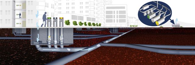
One of the most inspiring things I heard at the Vauxhall, Nine Elms, Battersea (VNEB) exhibition is the research undertaken into having the rubbish from all the new buildings removed by vacuum tubes rather than dust carts.

It sounds like science fiction but Sweden's Envac have 50 years experience of doing just this. And if it still sounds fanciful for this huge development project, they're working right this moment on a project of equivalent scale in Helsinki - with recycling thrown in of course.

How can this kind of scheme be encouraged and nurtured? The obvious starting point is to impose a limit on motor traffic, a vehicular 'gastric band'. That will bring this kind of imaginative thinking from pipe dream to pipe reality. Good grief, you'd even see drinking fountains and taps at railway stations as the sane replacement to lorry transported bottled water .

There's a load of guff talked by Boris about equality - giving people the choice to choose their mode of transport. The reality is that most kids and many other people would love to cycle to get to where they want to go but don't because the volume and speed of motor traffic,the lousy road layout, and the aggression of drivers make it an unequal option.

The way to liberate people to cycle and walk in the city is quite simply to throttle motor traffic and give the direct and easy route to the cyclist and pedestrian. Limit the capacity to the motorist, make them go around a maze or the M25 to get to their destination. But give the cyclist and pedestrian their desire line; give them cashpoints and drinking fountains, attractive shop frontages (or better, book and stuff library frontages) and riverside views. Put in loads and loads of hire bike docking stations.

Sure there'll still be a quantity of really unavoidable motor traffic but a lot will simply evaporate, as the dust cart example shows, and as the Netherlands have proven.

There are wider actions too, including making sure the planning regulations support local businesses, by providing affordable housing and workshop space alongside the swish apartments, rather than forcing them out of town resulting in vans and lorries trundling for miles and miles through residential streets just to get to inner London.

The plans for residential properties need to nurture active travel. If it's easier to jump in the car or in a cab than on the bike the design is failing.

VNEB can be the new Amsterdam.

A really good first action to implement in the next month or two with a bit of white paint and a couple of signs is for TfL take away one of the southbound lanes on Vauxhall Bridge from motor traffic so that the UNBELIEVABLY DIRE cycle lane becomes a delightful wide cycling boulevard instead. I've used the cycle lane twice recently on weekdays at 3.30pm and it made everything clench up. I can't believe that anyone responsible for roads could conceivably have cycled it and not immediately condemned it. What were the traffic 'engineers' who dreamt up such a monstrosity thinking, and why wouldn't a cycle friendly Mayor dramatically improve it immediately?

Thursday, 10 November 2011

Bring your kids on Saturday and tell Boris to have a reality check

I'm leading a ride for Cyclists in the City and I bike London bloggers on Saturday at 10.30am, from St Mark's Church on Clapham Road opposite the Oval tube station, around the ten locations with the highest number of collisions involving cyclists - the Elephant and Castle northern roundabout being top of the list. I urge you to come along, bring your kids and your grannies - As Boris said yesterday in Mayor's Question Time, "If you keep your wits about you, Elephant & Castle is perfectly negotiable."

He also said, ""I want people to feel confident. The cycle superhighways are about building confidence."


As an experienced motorist, cyclist, cycling instructor and trainer of cycling instructors I'd like to say that the E&C and the majority of the Cycling Superhighways are bloody awful for cycling - which is why you hardly see any secondary school children,  especially girls, cycling there.

Most of the motorists I know dislike many of TfL's roads and junctions, and they've undergone loads of training and a test! So what are the odds of your average soft, squidgy person who can't drive merrily pootling around these roads on bikes? Bugger all, and around here a huge number of households don't have a car. The Guardian recently reported that, nationally, the percentage of 17- to 20-year-olds with driving licences fell from 48% in the early 1990s to 35% last year. I bet it's nearer 20% locally so it's pretty damn optimistic for Boris to think that these people are going to be confidently cycling around the gyratories.

Does Boris really believe it's just lack of confidence that has the Head of Notre Dame secondary girls' school on St George's Road refusing to let her girls cycle to school? Or do you think it's because this is the road on which the school has its entrance?


Does Boris think the Head of Lilian Baylis Technology School on Kennington Lane, the edge of the congestion zone (below mid-morning) as it leads into the Vauxhall Gyratory, is completely deluded when he tells me that he suspects the challenge of these roads acts as a major barrier to his pupils cycling and their parents permitting it?


The off-road cycle option for the Vauxhall Gyratory is fragmented, obscure and takes forever to use. The semi-decent bit, if you can get to it, is used each day as a parking bay for the Tesco metro there (like the driver below today)  and I bet no-one has ever been fined for it.

In the world of Boris, is London Nautical secondary boys school on Stamford Street (above today) wrong in preferring that their pupils don't cycle over the Thames bridges to school? Can Boris really believe it's not an issue that the cycle lane on Waterloo Bridge disappears due to a pavement build out just as people zoom downhill to the roundabout?

Does he really consider the alternative route to avoid the foul Imax roundabout to be adequately signed?
And is the entrance to Waterloo Bridge off Upper Ground obvious to cyclists?
I know the teenage kids at these schools. Like any teenager they'll take the quick and easy option, not always paying total attention and sometimes being awry in their estimation of speed, position or intent.

In the Netherlands they work really hard to make the route for cyclists friendly, obvious, direct and safe, subjectively and statistically, because they want their children to cycle and they recognise their vulnerability.

Here Boris just tells the boys and girls to grow some cojones and jump in front of the HGVs.

What a buffoon.

Please join the ride to protest against his arrogance and TfL's apathy. And see if you can drag along one of our Councillors, none of whom have replied to my invitation. Finally, check out and share this short BBC newspiece

Friday, 4 November 2011

Will our local Councillors join the collision hotspots ride?

We live within a couple of miles of seven of the top 10 collision hotspots for cyclists in London. Cyclists in the City and I bike London have arranged a ride to review them on Saturday 12th November, starting at 10.30am by St Mark's Church, where the Oval Farmers' Market is, opposite Oval tube station.

You'll see me there in a Hi-Viz top at the front of the ride, as I've agreed to lead it (gulp!). There'll be at least 100 cyclists on the ride and, given that over 2000 turned up on Blackfriars Bridge recently, I hope there'll be even more to keep us company so please come along if you can. The route takes us through some of the most multi-lane motor-centric junctions in London, many of which have no clear, cycle-friendly and convenient alternative.

Just over a week ago I emailed the three Lambeth Councillors in Princes Ward, which has part of the Vauxhall Gyratory within it, and the three in Bishops Ward, which has the Imax roundabout in it. I invited them to join the ride or to speak to cyclists at these points about the actions they're working on to improve them for cyclists.

A week isn't a long time in politics and none of the Councillors have yet been in touch.
There's still a week to go and I'm sure we'll get at least one local Labour and one local LibDem Councillor along (nudge, nudge).

If you'd like to invite a Lambeth Councillor along their contact details can be found here.

Wednesday, 2 November 2011

Tell Lambeth not to pussyfoot around the Vauxhall Gyratory

Lambeth's Core Strategy, published in January this year, had this statement of intent:
highway improvements throughout the Vauxhall area particularly seeking the removal of the one-way traffic system

Lambeth's Labour group have now published a draft 'manifesto' for Lambeth which has a watered down version, with leader Steve Reed saying, "We will support residents who have asked TfL to remove the gyratory to create new open spaces and improve the area for pedestrians and cyclists."

Please email vnebmanifesto@gmail.com by 15 November telling them to stick to the Core Strategy statement rather than a wishy-washy statement on backing up the locals.